
AIS receiver & dispatcher with OpenSeaMap
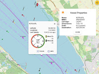
Updated 2023-11-09 ! The AIS posts on this blog have been very popular so this post will be a follow up which will enable You to show AIS targets, including AtoN:s, on OpenSeaMap , (OSM), together with buoys and beacons. The application showing the map is SignalK , (SK) a OpenSource project for marine use. With the " ais-forwarder " plugin you could send/dispatch the NMEA AIS data to Marinetraffic or Vesselfinder . Another AIS-dispatcher . The best AIS application ? is found here !


