OpenPlotter, V1, quick install guide

Updated 2020-01-13 !
OpenPlotter is;
- A complete boat navigation system
- Includes OpenCPN, Chart plotter navigation
- OpenSource, so it's free !
- Running on Raspberry Pi(RPi)
- Its hardware is cheap
- Running on Unix, so its reliable
I really don't recommend this old OP 1, instead check out OP V2, stable, which works very well !
OP is also a compilation of several other nice software which makes it a fantastic package for additional functions.
The Openplotter WEB-site, the nice forum with active people and god documentation makes it almost easy, but if You are a newbie to both OpenPlotter(OP) and OpenCPN(OC), as I was, it can be to much.....
So I'm trying to do a compact guide with links to the documentation and, hopefully, a fast way to be up and running.
Probably You are doing the first setup at home so you don't have any hardware connected to Your boat network, but thats no problem.
SignalK(SK) is mentioned several times in the documentation and You should know that this is the "engine" in OP, but for now thats all You have to know.
If You don't care about the extra OP software You can run SK standalone.
Install the OP programs. For the the moment, 2018-11-09, download and use the v1 image. Don't use the OpenPlotter v1.0.0 NOOBS which I could't get to work.
Use Etcher to copy the image to the SD card or with a Mac
sudo dd bs=1m if=openplotter_v1.0.0.img of=/dev/disk3
The copy, almost 6 Gb, on an old Mac, took about 40 minutes.
Connect to the Rpi via WiFi. I used the "VNC Viewer" on my Mac which also works great on an iPad. If You have connected the RPi, with cable to Your Ethernet, check the given IP-address via Your gateway. Then use this IP address, in VNC, instead of connecting the Openplotter WiFi.
Using VNC and logged on to the RPI, do the "Raspberry Pi Configuration" settings in this document
If necessary change the resolution
"Preferences" => "RPi Config" => "System" => "Set Resolution".
I picked => DMT mode 16, 1024 x 768 to work together with my Mac
Then it is time to update the installation.
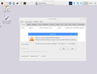
- Open OP, clicking on the anchor symbol in the upper part of the VNC window
- In the new window click on "Updates"
- Click on "Update OpenPlotter".
- A terminal window will open and the process will start
- It could be that You have to type "q" or "y", to let the process continue
- On my RPi 3 it took about 20 minutes and ends with FINISHED, PRESS ENTER TO REBOOT SYSTEM

Please note that if You don't log on, in SK, You will not be able to do any settings.
You can get some hints of the SignalK setup in the end of this document
Prior V 1.x.x
To check that OpenCPN, the plotter, works, without any NMEA physical input we use the "NMEA 0183 generator"
Start the OP application by clicking on the "Anchor" symbol in the upper part of the window
Go to the "Tools" Meny and klick on "NMEA 0183 generator". At the end of document there is a guide. Klick on "add" and select "RMC" from the sentence drop down list and "1" from the Rate(sec) drop down.
RMC means Recommended Minimum Navigation Information and are a sentence sent from an GPS. If You click on the "NMEA info" button You will have an explanation for all valid sentences. WEB link
Add "Type" and "Value" to respective field
| Field | Type | Value | Remark |
|---|---|---|---|
| Timestamp | Number | 100000 | 24 hour clock |
| Status | String | A | |
| Latitude | Number | 5607.010 | |
| Latitude Direction | String | N | |
| Longitude | Number | 01236.309 | |
| Longitude Direction | String | E | |
| Speed Over Ground | Number | 5 | |
| True Course | Number | 270 | |
| Datestamp | Number | 180418 | DDMMYY |
| Magnetic Variation | |||
| Magnetic Variation Direction |
and finish with a click on the "OK" button
Open OC by clicking on the icon on the desktop. Klick on the "drop", "Auto Follow", in the meny at the top and You should see a worldmap with Your Boat placed in the south of Sweden.
In the lower left part of the OC window You will see the actual coordinates, SOG, speed over ground and COG, Course over ground.
End
This ends the initial installation and now You can continue with the USB sensors
or using the log files in SignalK to simulate a trip in the south of Finland displayed in OpenCPN.
A really nice iOS application, to display all the navigation data, is WilhelmSK and here is more info.


Thanks for great post. After more than a day struggling I found your blog and followed it with only a few hitches. Still cant get Openplotter anchor on menu bar
ReplyDeleteThx, strange with the anchor ? Don't forget to check out the new Beta, https://pysselilivet.blogspot.com/2019/08/openplotter-beta-v2-quick-install-guide.html , it will really make it more simple in the future.
Delete